
By Grace Murphy
Randolph County, West Virginia lies at the edge of the Appalachian Plateau, a landform which covers much of the rest of the state. It is within the plateau’s Allegheny section while its eastern extremes cross the Allegheny Structural Front which separates the aforementioned plateau from the Valley and Ridge Appalachians to the east. This portion of the plateau is marked by folds that have been molded into ridges and their accompanying valleys by a dendritic, tentacle-like network of streams. These folds being high enough to be termed mountains, the region was dubbed the Allegheny Mountains by early settlers. This region proved a raucous transitional area that presented a challenge to these individuals. Besides topography, settlers’ travels were complicated by the obstacles of politics and preceding communities of Native Americans. Today’s Allegheny towns, villages, and cities descend from these settlement efforts–some preserving buildings that make this fierce history tangible, even if it is obscured at first glance.
Trans-Allegheny settlement was originally encouraged by English officials who thought the Crown could benefit economically as well as establish more extensive frontier defences as Europeans westward. This movement was aided by the 1722 Treaty of Albany and the 1744 Treaty of Lancaster, both made between the British and Haudenosaunee (Iroquois) Confederacy. The earlier treaty saw the Haudenosaunee concede to settlement south of the Potomac River, but east of Alleghenies. The latter generally reaffirmed these terms, but was interpreted by land speculators and government officials as a relinquishing of Haudenosaunee claims as far west as the Ohio River. The Ohio River was particularly attractive as a means of accessing the Mississippi River and eventually the port city of New Orleans. The area west of the Alleghenies was, in terms of European colonization, traditionally held by the French. The influx of British settlement–more than 2 million land grants were issued between 1745 and 1754 for lands within the trans-Allegheny region–were a major contributing factor of the French and Indian War (1754-1763), the North American theater of the broader Seven Years’ War. At the conclusion of this conflict, the Treaty of Paris, the French holdings in Canada and the Ohio Country were surrendered to the victorious British. This cession of lands angered Native groups who viewed the French as having no right to hand over these lands for British settlement. Thus, soon after the Treaty of Paris came Pontiac’s War, named for an Ottawa chief. This conflict was characterized by Native raiding of frontier settlements in New York, Pennsylvania, Maryland, and Virginia. Notably, in an attempt to pacify Natives and better control settlers, King George III issued the Proclamation Line of 1763 in October of that year, forbidding trans-Allegheny settlement. Pontiac’s War ended roughly a year later.
The proclamation was ill-received by settlers, being viewed as an encroachment of their rights. For example, western farmers exercised a degree of freedom from the mercantilist system by illicitly trading goods with Natives, a practice the Crown was aware of and hoped to discourage with the proclamation line. More pointedly, settlers bristled at the act’s effective recognition of Native land rights and ownership. However, the wilderness was spacious and London far, far away. There was also still the matter of the millions of land grants handed out in the years preceding the French and Indian War. These grants held by settlers and land speculators represented a route to western lands that were presumed to be fertile, much more so than the settled eastern earth that had been cultivated in some way for over a century by 1763. As rich as the land was thought to be, westward movement presented mental roadblocks as much as it did physical and topographical ones.
Settlers feared the unfamiliar, uncivilized expanses where “barbaric” Natives far outnumbered any individuals of European stock. Indeed, it is thought that John and Samuel Pringle, brothers who deserted Fort Pitt and came to the Buckhannon River in 1764 and who lived in a hollow sycamore tree until the end of the decade, and John Simpson who had a camp near Clarksburg, were the only occupants of the Monongahela Valley south of Pennsylvania as of the 1760s. It is said–arguably erroneously–that Samuel Pringle, his brother, and two other deserters were the first permanent occupants of the trans-Allegheny region of then-western Virginia. Evidently, the soldiers sent from Pittsburgh to the region in 1766 to flush out trespassers of the 1763 line missed these individuals. The 1768 Treaties of Hard Labor and Fort Stanwix pushed the settlement line west towards the Ohio River and south to the mouth of the Kanawha River. The former treaty was between the British and the Cherokee. The latter was between the British, the Haudenosaunee Confederacy (Mohawk, Oneida, Onondaga, Cayuga, and Seneca), the Cayuga, the Delaware, and the Tuscarora. With these, nearly all of West Virginia’s modern land mass was available for settlement according to the British officials.
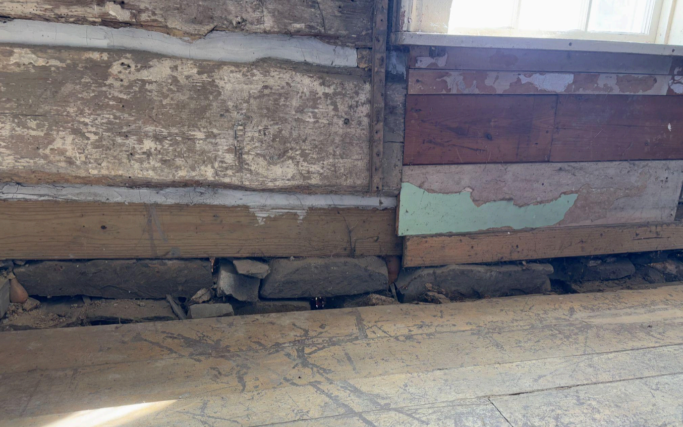
Logs seen from inside the first floor of the Collett House.
The story of Beverly in Randolph County bears witness to this tangled settlement history. The earliest families to have arrived in the area were those of Robert Files (Foles) and David Tygart (Taggart) in 1753, a year before the commencement of the French and Indian War. In 1754, nearly the entire Files family was killed by Native Americans. It is of note that the families had already been planning a return to the east as the land proved difficult to cultivate and their grain yield was very low. The violent scene was partially witnessed by one Files boy who had been out and who, upon realizing he could not help his family, ran to the Tygart home to alert them. These settlers’ are immortalized by Files’ Creek and the Tygart Valley and its accompanying river. With time, the Tygart Valley would again attract settlers. During the 18 years between the family massacre and the time when a group of permanent settlers would return, the valley hosted hunters from the Greenbrier region. These hunters praised this valley. It boasted a wide expanse of level land surrounded by imposing ridges as well as plenty of wild game. Indeed, West Virginia’s last buffalo was felled in the valley in 1825 and elk still existed on the Cheat Mountain ranges, which stand to the valley’s east, by the time of the Civil War. Between 1754 and 1772, the area had only sporadic attempts at settlement.
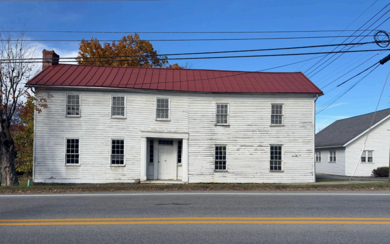
The group of new permanent settlers arrived in the area of Beverly in 1772. This group was led by Captain Benjamin Wilson and was comprised of nine families; the Westfalls; the Stalnakers; the Butlers; the Whitmans; the Connelys; the Nelsons; the Riggles; the Haddens; and the Morgans. Soon after their arrival, Beverly’s oldest buildings were constructed. These included Jacob Westfall’s fort near the former Files homestead, where the Westfalls discovered the family’s remains and had them buried, James Westfall’s fort, and what is today known as the Buckey House. James Westfall’s fort is contained within the building now known as the Collett House for a 19th century owner. This fort is thought to have been built between 1772 and 1774 to provide settlers with protection from Natives. The timing could hardly have been a coincidence with the settlers arriving at the earlier date and 1774 being marked by increased settler-Native hostilities, known as Lord Dunmore’s War, in Virginia out to the Ohio Country. Like the Buckey House, the Collett House is located along Main Street and has been finished with siding and expanded on over the years, obscuring the original log structure from the road. Evidently, this second go at settlement was much more successful as the town formerly known as Edmundton was renamed as Beverly in 1790. The town was planned on 20 acres owned by James Westfall and was intended from the start to serve as the county seat of Randolph County, itself established only three years prior.
Trans-Allegheny settlement was a herculean feat for mid and late 18th century settlers. At a most basic level, they had the rugged terrain of the region staring down at them as they set off to climb ridges to reach valleys suitable for living. Then there was the matter of Natives who had preexisting ties to the land which were founded on a wildly different conception of land ownership. There was political discord and red tape in the form of the French and Indian War and the ensuing Proclamation Line of 1863. At a conceptual level, settlers faced a wilderness that stood in stark contrast with the comparatively civilized world of the east. Beverly’s town history is a microcosm of these disquieting times. Buildings such as the Collett House serve as physical manifestations of the many strands of historical narratives that have fed the places we now live and steward.
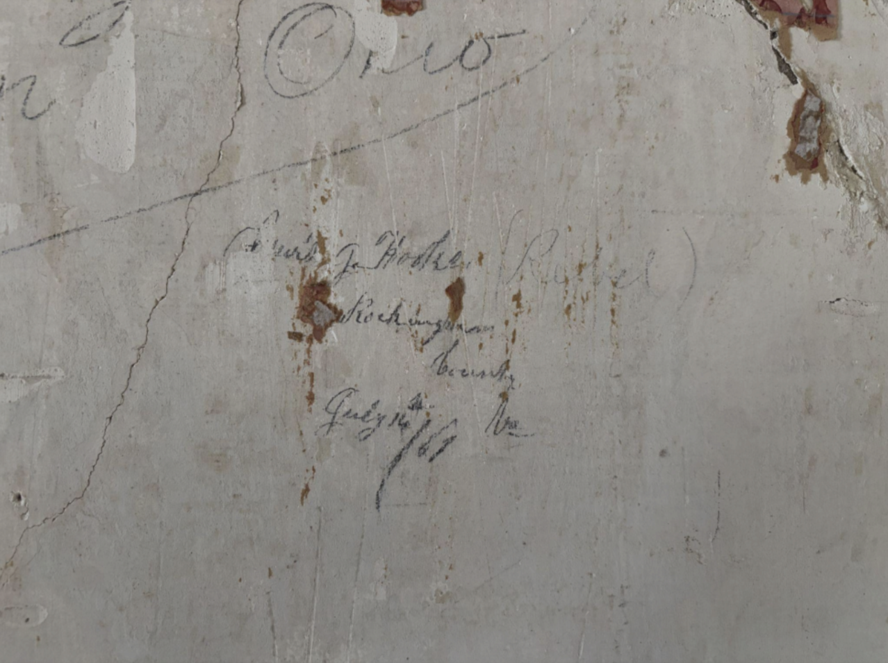
The oldest known example of Civil War graffiti is located in one of the upstairs rooms of the
Collett House. It dates to July 1861 and was left by a Confederate soldier imprisoned in the
house after the Battle of Rich Mountain. In this way, the Collett House aptly intertwines
Beverly’s earliest history with a later era it is closely with which it is closely identified.
References
“Beverly Historic District.” National Register of Historic Places nomination, 1980. United States
Department of the Interior. https://wvculture.org/wp-content/uploads/2021/03/Beverly-historic-district.pdf.
Bosworth, A.S. A History of Randolph County West Virginia: From its Earliest Exploration and
Settlement to the Present Time. 1916.
Fast, Richard Ellsworth, and Hu Maxwell. History and Government of West Virginia.
Morgantown, WV: The Acme Publishing Company, 1901.
McBride, W. Stephen, Kim Abrogast McBride, and Greg Adamson. Frontier Forts in West
Virginia: Historical and archaeological explorations. Charleston, WV: West Virginia
Division of Culture and History, 2003.
McCutchen, Jennifer Monroe. “Proclamation Line of 1763.” George Washington’s Mount
Vernon. Accessed December 10, 2025. https://www.mountvernon.org/library/digitalhistory/digital-encyclopedia/article/proclama
tion-line-of-1763.
McWhorter, Lucullus Virgil. The Border Settlers of Northwestern Virginia From 1768 to 1795:
Embracing the Life of Jesse Hughes and Other Noted Scouts of the Great Woods of the
Trans-Allegheny with Notes and Illustrative Anecdotes. Hamilton, OH: The Republican
Publishing Company, 1915.
“Physiographic Provinces of West Virginia.” WVGES: West Virginia Geological & Economic
Survey, January 6, 2020. https://www.wvgs.wvnet.edu/www/maps/pprovinces.htm.
Presson, Erin, "The Moving West: The Formation of the American Midwest Through Westward
Expansion." Master’s thesis, Washington University in St. Louis, 2010.
https://openscholarship.wustl.edu/etd/456.
Renton, John J. and Thomas Repine. “The Geology of West Virginia.” Readings and Notes 26
(2016). https://researchrepository.wvu.edu/earthscience_readings/26.
“Treaty of Fort Stanwix, 1768.” Tribal Treaties Database. Accessed December 10, 2025.
https://treaties.okstate.edu/treaties/treaty-of-fort-stanwix-1768-21783.
Zimmerman, Courtney Fint, and Aurora Research Associates, LLC. Beverly, West Virginia
National Register Historic District Architectural Survey Update, 2014.